07/01/2026 – Weather in Cornwall
Ice Warning Overnight Could Catch Morning Commuters Out
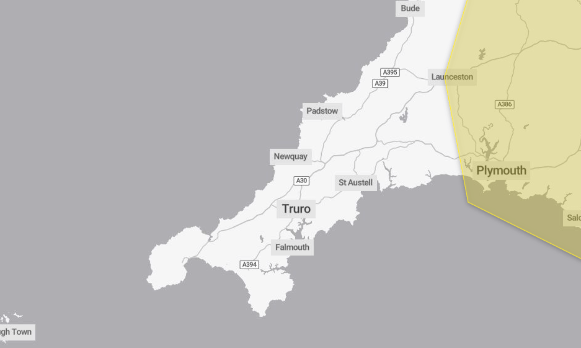
A yellow weather warning for ice has been issued by the Met Office, covering the period from 7.31pm on Tuesday 6th January through to 10.00am today, Wednesday 7th January.
The warning highlights the risk of icy patches developing overnight into Wednesday morning, with the potential for some minor disruption.
What is expected
According to the warning, icy patches are likely to form on untreated wet surfaces after a band of precipitation clears southeast overnight. With clear skies developing across many areas, temperatures are expected to drop enough for ice to form.
This could lead to some injuries from slips and falls on icy surfaces. Untreated roads, pavements and cycle paths are most likely to be affected, particularly during the early morning.
Advice for staying safe
People are advised to take extra care when heading out. Leaving the house at least five minutes earlier than usual can help reduce the need to rush, lowering the risk of accidents, slips and falls.
Anyone travelling on foot is encouraged to use pavements along main roads, which are more likely to be less slippery. Cyclists are also advised to stick to main roads where possible, as these are more likely to have been treated.
Drivers are being advised to check road conditions before setting off, while bus and train users should check timetables and be prepared to amend travel plans if needed.
The Met Office also recommends staying up to date with local forecasts, as weather warnings can change.
Why the warning is yellow
The ice warning has been classed as yellow because it has a medium likelihood and a low impact, meaning disruption is possible but expected to be limited, particularly during the Wednesday morning commute.
South West England weather forecast
Headline:
Some sunshine with rain and drizzle arriving later.
Today:
Another cold day for many with some ice at first, especially in the east. Bright or sunny spells. Rain then edging in across Cornwall and west Devon by late afternoon. Gusty winds and feeling slightly less cold. Maximum temperature 7 °C.
Tonight:
A murky evening with cloud, patchy rain and drizzle moving eastwards. Turning drier overnight with some clearer spells. Further rain in the far west by dawn. Winds easing. Minimum temperature 2 °C.
Thursday:
Some early bright spells, but soon turning increasingly unsettled from the southwest, with heavy rain, mainly hill snow and strong winds developing with coastal gales. Still feeling chilly. Maximum temperature 9 °C.
Outlook for Friday to Sunday:
Rain and snow clearing eastwards leaving showers on Friday. Gales easing. Brighter and drier on Saturday, with frost early and late. Rain and strong winds returning on Sunday. Remaining cold.
Updated:
Share This Story, Choose Your Platform!
To keep up with the latest cornish news follow us below
Follow CornishStuff on Facebook - Like our Facebook page to get the latest news in your feed and join in the discussions in the comments. Click here to give us a like!
Follow us on Twitter - For the latest breaking news in Cornwall and the latest stories, click here to follow CornishStuff on X.
Follow us on Instagram - We also put the latest news in our Instagram Stories. Click here to follow CornishStuff on Instagram.
You Might Also Be Interested In


Don’t Miss What’s Happening in Cornwall
Join others in Cornwall by receiving the latest daily news in Cornwall, sent direct to your inbox.