08/12/2025 – Weather in Cornwall – Yellow Weather Warning For Wind & Rain
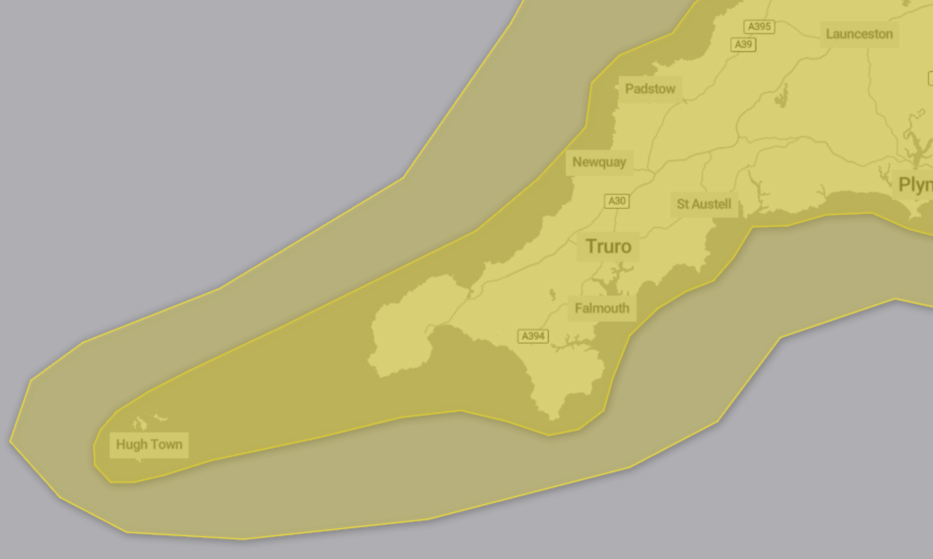
The Met Office has issued two yellow weather warnings from today into Tuesday, with strong winds and heavy rain expected to cause disruption across the region.
Strong Winds Overnight into Tuesday
A yellow warning for wind is in place from 22:00 today until 16:00 tomorrow. According to the Met Office, strong south to southwesterly winds will build through Monday night and stay gusty into Tuesday morning before easing during the afternoon.
Peak gusts of 40 to 50 mph are expected widely. Along exposed coasts and over or north of high ground, gusts could reach 60 to 70 mph. There is also a small chance of gusts topping 70 mph over northwest Wales.
What to Expect
The Met Office states:
-
Some delays to road, rail, air and ferry transport are likely
-
Bus and train services may take longer
-
Delays for high sided vehicles on exposed routes and bridges are likely
-
Some short term loss of power and other services is possible
-
Coastal routes, sea fronts and coastal communities may be affected by spray or large waves
Advice from the Met Office
People are encouraged to check road conditions, bus and train timetables, and amend travel plans if needed.
The guidance adds that preparing for potential power cuts can help, suggesting torches, batteries and mobile power packs as useful items to gather.
Coastal safety is also highlighted. Large waves can sweep people off their feet, even from the shore. Walkers are urged to take care near cliffs, know their route and keep dogs on leads. In an emergency, call 999 and ask for the Coastguard.
The Met Office reminds people to stay updated in case warnings change.
The wind warning is classed as yellow due to a medium likelihood and a low impact.
Heavy Rain Set to Bring Flood Risk
A second yellow warning, for rain, runs from 18:00 today until 18:00 tomorrow. Persistent and heavy rain is expected overnight, with further heavy bursts possible through Tuesday.
Rainfall totals of 20 to 40 mm are likely in many places, with 60 to 80 mm over Dartmoor and high ground in Wales. The Met Office says there is a small chance of 80 to 100 mm on the most exposed hills. With the ground already saturated, some flooding and transport disruption are likely. Strengthening southerly winds may make impacts worse.
What to Expect
According to the Met Office:
-
Homes and businesses could be flooded
-
Fast flowing or deep floodwater could pose a danger to life
-
Train and bus services may be delayed or cancelled
-
Driving conditions may be difficult, with spray and flooding leading to road closures
-
Some communities may be cut off by flooded roads
-
There is a slight chance of power cuts and loss of other services
Advice from the Met Office
People are advised to check whether their property is at risk of flooding and consider preparing a flood plan or emergency flood kit.
Travellers are encouraged to check road conditions and public transport timetables.
As with the wind warning, advance preparation for possible power cuts is recommended.
The Met Office reminds people to stay updated in case warnings change.
This rain warning is yellow due to a low likelihood and a medium impact.
South West England weather forecast
Headline:
Heavy rain, gales and flooding possible tonight and into tomorrow.
Today:
Showers quickly clearing, leaving brighter skies for a time. Cloud then thickening with perhaps some showery rain in places. Another mild day. Heavy rain arriving later and through this evening. Maximum temperature 13 °C.
Tonight:
Quickly becoming very wet this evening. Heavy rain continuing overnight with travel disruption and flooding possible in places. Strong southerly winds developing with gales in places later. Becoming very mild. Minimum temperature 11 °C.
Tuesday:
Mainly cloudy with outbreaks of rain and drizzle through the morning, heavy over higher ground at first. Brightening up through the afternoon. Gales easing but staying windy. Exceptionally mild. Maximum temperature 15 °C.
Outlook for Wednesday to Friday:
Drier and brighter on Wednesday with sunny periods and isolated showers. Probably dry with bright spells on Thursday. Rain likely at times on Friday. Often rather windy. Staying very mild.
Updated:
Share This Story, Choose Your Platform!
To keep up with the latest cornish news follow us below
Follow CornishStuff on Facebook - Like our Facebook page to get the latest news in your feed and join in the discussions in the comments. Click here to give us a like!
Follow us on Twitter - For the latest breaking news in Cornwall and the latest stories, click here to follow CornishStuff on X.
Follow us on Instagram - We also put the latest news in our Instagram Stories. Click here to follow CornishStuff on Instagram.
You Might Also Be Interested In


Don’t Miss What’s Happening in Cornwall
Join others in Cornwall by receiving the latest daily news in Cornwall, sent direct to your inbox.