Flood Alerts Issued Across Cornwall as High Tides and Heavy Rain Forecast
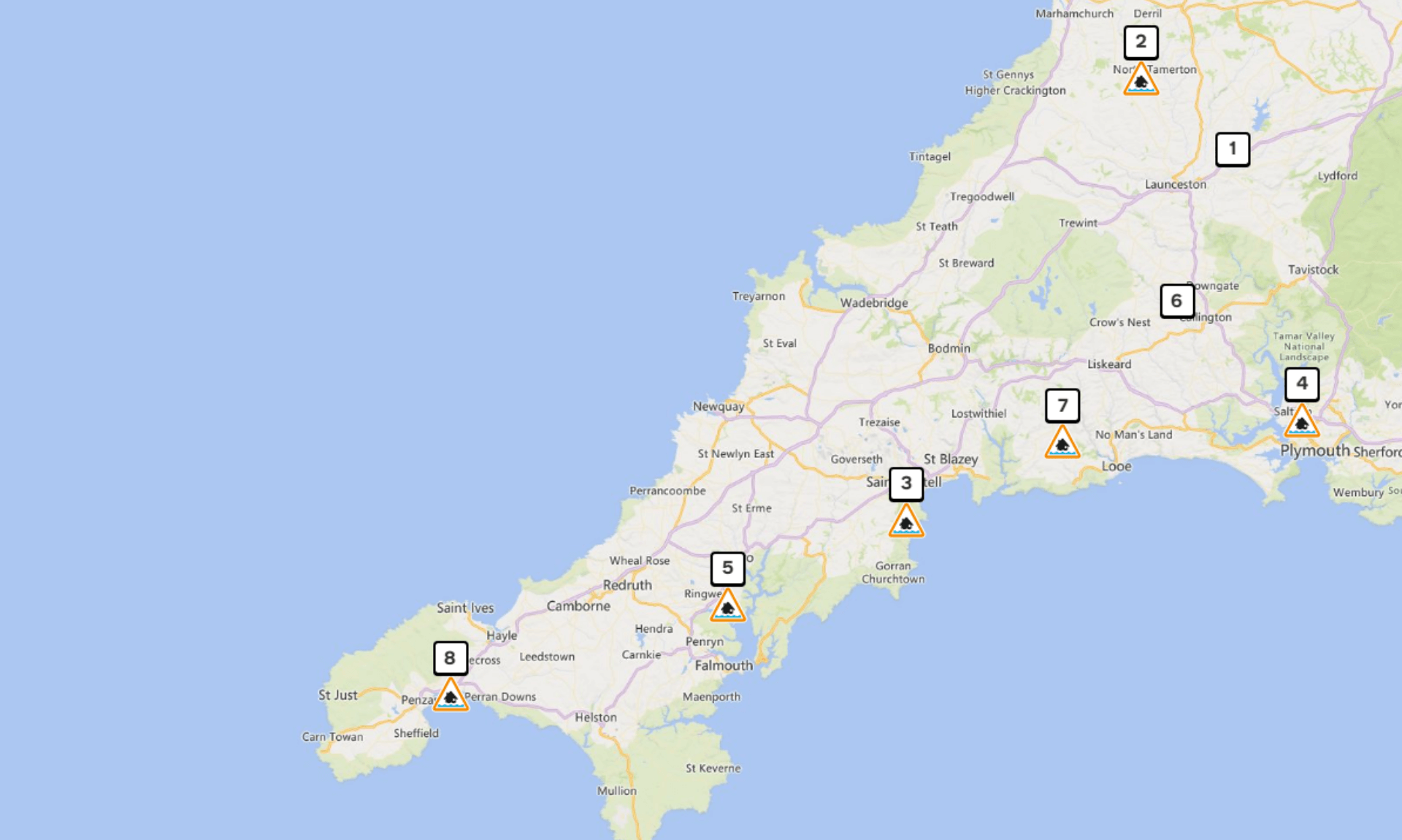
Flood alerts have been issued for large parts of Cornwall, with flooding possible from this evening, Thursday 22nd January, through to Saturday as heavy rain, strong winds and high tides combine.
The Environment Agency says there is a particular risk around high tide, urging people in flood risk areas to take steps to protect their property and to never walk or drive through floodwater, which can be deeper than it appears.
Further alerts and warnings may be issued as conditions change, with updates expected by 3:00pm on Friday 23rd January 2026.
South Cornwall Coast: Gribbin Head to Rame Head
Flooding is possible up to two hours either side of high tide on Thursday evening and Friday morning.
Areas at risk include Fowey, Lostwithiel, Polperro, Looe, Millendreath and Seaton, including quays, harbours, car parks and recreation areas.
High tide at Plymouth is at 8:11pm on Thursday and 8:24am on Friday. Forecast tide levels are expected to be between 0.4m and 0.7m above tide table levels, with offshore waves of around 3m and winds strengthening from south westerly to south easterly.
South Cornwall Coast: Land’s End to Lizard Point
Flooding is again possible around high tide on Thursday evening and Friday morning.
Locations particularly at risk include Mousehole, Newlyn, Penzance, Marazion, Praa Sands and Porthleven.
High tide at Newlyn is at 7:03pm on Thursday and 7:23am on Friday. Offshore wave heights of up to 4m are forecast, with winds increasing to Force 6 from the south east.
South Cornwall Coast: Lizard Point to Gribbin Head
This alert excludes the tidal Fal Estuary but covers several coastal communities.
Areas at risk include Falmouth, St Mawes, Mevagissey, Pentewan and Par, along with the tidal Helford Estuary.
High tide at Falmouth is at 7:27pm on Thursday and 7:44am on Friday. Wave heights of around 2.8m are forecast, with similar increases in tide levels above predicted tables.
Tidal Fal Estuary
Low lying areas are particularly vulnerable, including parts of Penryn, Mylor Bridge and the A39 at Perranarworthal.
Conditions mirror those along the south coast, with high tides, increased wave heights and strengthening winds expected through Friday morning.
Upper River Tamar
Away from the coast, rising river levels may also lead to flooding.
Flooding is possible from 14:15 on Thursday 22nd January, with low lying land and roads near rivers most affected. Areas covered by this alert include Bude, Launceston and surrounding communities.
Heavy rainfall has already caused river levels to rise, and further showers are forecast, meaning levels are expected to remain high into Friday.
Safety Advice
People are advised to avoid coastal roads, footpaths and car parks that may flood, and to take care not to walk, cycle or drive through floodwater.
The Environment Agency says it is closely monitoring the situation and will issue further updates as needed.
Share This Story, Choose Your Platform!
To keep up with the latest cornish news follow us below
Follow CornishStuff on Facebook - Like our Facebook page to get the latest news in your feed and join in the discussions in the comments. Click here to give us a like!
Follow us on Twitter - For the latest breaking news in Cornwall and the latest stories, click here to follow CornishStuff on X.
Follow us on Instagram - We also put the latest news in our Instagram Stories. Click here to follow CornishStuff on Instagram.
You Might Also Be Interested In


Don’t Miss What’s Happening in Cornwall
Join others in Cornwall by receiving the latest daily news in Cornwall, sent direct to your inbox.