19/07/2025 – Weather in Cornwall – Yellow Weather Warning For Rain
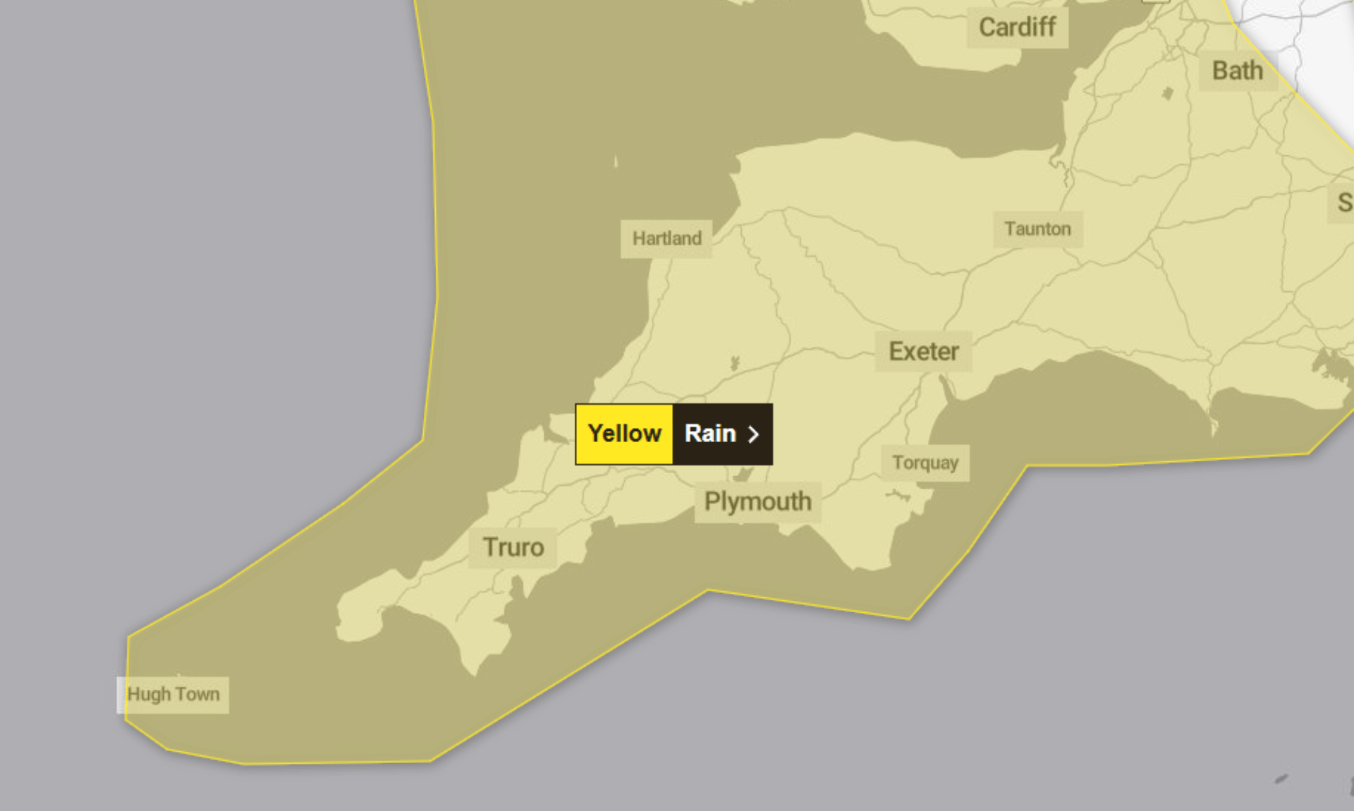
The Met Office has issued a yellow weather warning for rain covering Cornwall and the wider South West, in effect from 6pm on Saturday 19th July until 9pm on Sunday 20th July.
What to Expect
Heavy rain and isolated thunderstorms are forecast to begin across southwest England this evening, moving into Wales by Sunday morning. More downpours and thunderstorms are likely to develop throughout Sunday.
According to the Met Office, rainfall may reach 30 to 50 mm in just a few hours, with a small chance that some locations could see 75 mm or more.
This could lead to:
-
Localised flooding and damage to buildings
-
Transport disruption including possible delays or cancellations to bus and train services
-
Spray and floodwater making driving hazardous and potentially closing roads
-
Power cuts and temporary loss of other services to homes and businesses
-
A small chance of fast-flowing or deep floodwater causing danger to life
-
Some communities potentially becoming cut off by flooded roads
Stay Safe and Prepare
The Met Office advises residents to check if their property is at risk of flooding and to consider preparing a flood plan and emergency flood kit. If you’re travelling, it’s worth checking road conditions, train and bus timetables, and being prepared to amend your plans.
For power cuts, consider gathering essentials like torches and batteries, a mobile phone power pack, and any other critical items.
The Met Office also reminds people that weather warnings can change quickly and recommends staying up to date with forecasts in your area. You can find updates directly on the Met Office website.
This yellow warning has been issued due to very low likelihood but medium impact conditions.
South West England weather forecast
Headline:
Heavy showers mixed with occasional brighter spells.
Today:
A mixture of sunshine and showers, these heaviest and carrying the risk of thunderstorms and hail in the east. Sunny spells further west, before rain arrives in the southwest later. Maximum temperature 23 °C.
Tonight:
Turning cloudier this evening from the west with heavy outbreaks of rain pushing northeastwards overnight. Winds strengthening, especially around the coasts and feeling humid. Minimum temperature 14 °C.
Sunday:
Unsettled with further spells of heavy rain and thundery downpours. Some brighter and drier interludes possible and remaining breezy. Maximum temperature 21 °C.
Outlook for Monday to Wednesday:
Somewhat drier through the period with occasional bright spells but always the risk of the odd heavy and longer spells of rain. Feeling warm in the sunshine but often breezy.
Updated:
Share This Story, Choose Your Platform!
To keep up with the latest cornish news follow us below
Follow CornishStuff on Facebook - Like our Facebook page to get the latest news in your feed and join in the discussions in the comments. Click here to give us a like!
Follow us on Twitter - For the latest breaking news in Cornwall and the latest stories, click here to follow CornishStuff on X.
Follow us on Instagram - We also put the latest news in our Instagram Stories. Click here to follow CornishStuff on Instagram.
You Might Also Be Interested In


Don’t Miss What’s Happening in Cornwall
Join others in Cornwall by receiving the latest daily news in Cornwall, sent direct to your inbox.